The seminar course ‚Analysis and Modelling‘ built upon the introductory course ‚Methods in Spatial Analysis‘ and offered the opportunity to focus on a selected method inside a larger project and explore the capabilities more in depth. Results should be then finalized in form of a seminar paper.
I decided to choose the topic of procedural city modelling. Procedural modelling is modelling based on defined rulesets and is opposed to traditional manual modelling. As computational capabilities increase, procedural modelling becomes more compelling. As vast urban areas are notoriously hard to model and manual modelling is time and resource intensive, procedural modelling seems to be an attractive alternative. This seminar work seeks to evaluate current advantages and disadvantages of procedural city modelling based on the ESRI CityEngine software.

What is City Modelling?
City models are 3D representations of urban areas containing features like streets, buildings, vegetation and other elements which provide geospatial information. They can be used to present, explore, analyse and manage spatially related information in cities. 3D models make data more versatile and accessible for non-geographers as it is visually closer to reality. They can also enable new ways of interaction with data (e.g. visualization of floor space or physical simulations) and by that can improve urban planning capabilities.
The approach to city management by displaying spatial data via city models becomes increasingly important with the spread of new concepts like digital twin cities and smart cities which increase the demand for highly detailed city models for the purpose of visualising various datasets.

Procedural Modelling
Procedural modelling or rule-based modelling describes a number of techniques in computer graphics to create 3D models and textures from a set of rules. Alternatives to this approach are manual modelling or scanning of existing objects (Photogrammetry). The overall quality of the grammar-based description is reflected in the quality and number of details of the generated models.
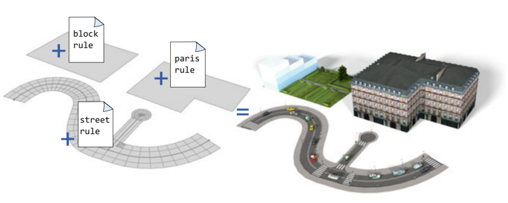
The key advantage of procedural modelling against manual modelling, is the rapid generation and automation of models based on defined rules. This allows the user to create massive cities in a very short time and with low costs. Procedural Modelling is especially useful if you do not have any existing models or features you can build upon, but want to create realistic looking models. The accuracy of procedurally generated models can be further enriched by attributes stored in GIS data, for example building heights and roof types, but they are not mandatory for the creation of rule-based city models.
More in-depth information about my city modelling approach and underlying concepts can be read in my story map about procedural city modelling.
Modelling the city district of Itzling, Salzburg
Itzling is a city district in the north of Salzburg, located between the river Salzach in the west and the railway lines in the east. Main building types are single-family residential homes, multi-family building blocks in the north and larger business and industry buildings located along Rosa-Kerschbaumer-Straße. The main processing of the building models was based on the building footprints that included important additional information such as size, height, and average slope of the building roofs. The goal was to create a detailed city model, which should include buildings with various types of roofs, individual windows, and different textures. Additionally, street networks and terrain should be visualized.
Final 3D Model