The course ‚I3 Project‘, short for interdisciplinary, integrated, interactive project was a late master’s seminar course that prepares students for their master’s thesis by helping to develop, test, and validate their competencies in a first large scientific project. Students were challenged with a major project to be completed through all its stages. From problem analysis, conceptualization, work flow design and data acquisition to schema implementation, analyses, validation and communication of essential outcomes, all major phases of a project were practiced. For this task every student could select a topic of interest and work on the project throughout the semester. Several meetings ensured that progress was made.

Pump Track Analysis
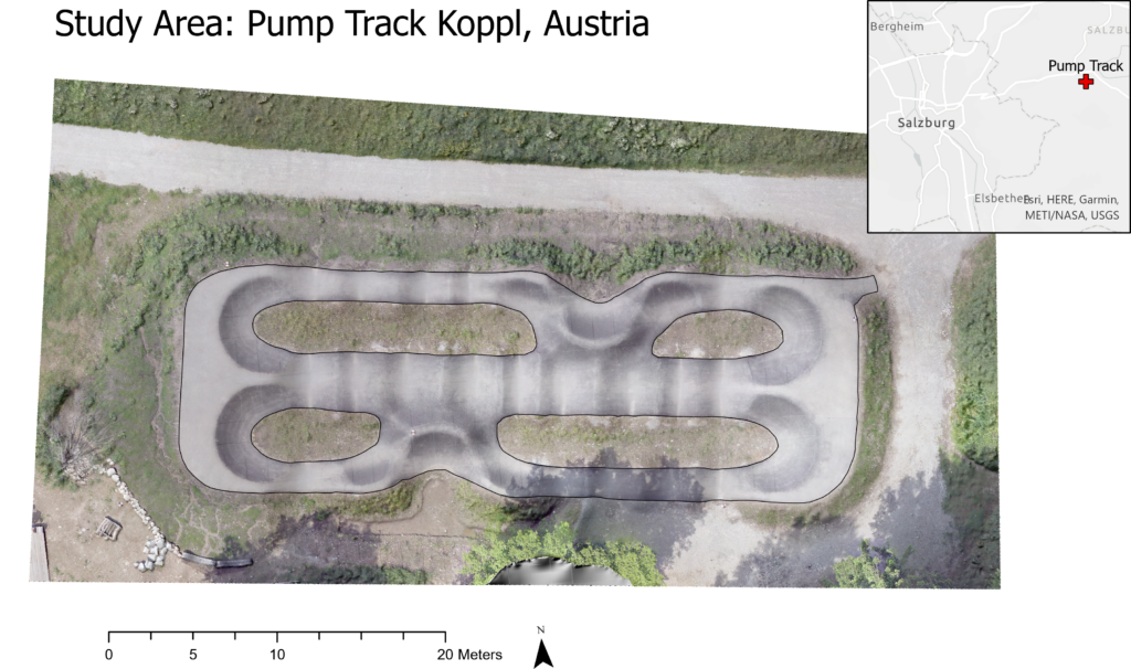
For my personal topic I decided to explore the possibility to use OBIA and geomorphometry to analyze pump track surfaces. Why? Professional mountain biking sports have become increasingly popular in recent years. To train the traversal through complex terrain, special pump tracks have been designed. They provide mountain bikers the option to generate momentum by up and down body movements instead of pedalling and thereby to efficiently move through obstacles and morphological features. This project did research if object-based image analysis (OBIA) methods are good way to analyze and potentially improve pump track designs on the example of the pump track in Koppl, Salzburg. Existing very high-resolution imagery of the study area enabled the creation of high-quality digital elevation models which were then analysed regarding their morphometry. This could give new insights into the functions of pump tracks and thereby help improving their design to better meet the needs of mountain bikers. As a secondary goal this project did seek to find out whether OBIA is suited as a method of choice for the analysis of small-scale areas and very-high resolution datasets.
Potential stakeholders for this type of research were pump track designer and companies involved in the building of such tracks, the mountain biker and end-user of the tracks, as well as researchers and developers.
Key objectives were:
- to create analysis workflow which incorporates OBIA methods
- to develop a classification schema that covers all relevant geomorphological forms and features
- to create according rulesets that segment and classify the DEM
- to automate the workflow
- to ensure transferability of analysis to other pump tracks
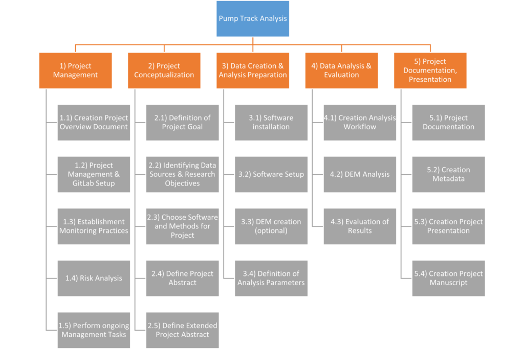
Project Management
As the project was rather large and should amount to 300 working hours in total, comprehensive project management was necessary. For this task, multiple overview documents and charts were created to get an overview of the project’s progress and development, including a work breakdown structure into individual tasks, a gantt chart, a risk matrix, work package and task descriptions, as well as a list of milestones and deliverables. The project work was documented on GitLab.
What is Geomorphometry?
There have been multiple takes on the definition of the term geomorphometry. Most have in common that geomorphometry is defined as the science of quantitative land-surface analysis. Modern geomorphometry incorporates methods and techniques from the domains of mathematics, the Earth sciences, and computer science. Most geomorphometric research is centred around the creation and analysis of digital terrain models and other derivatives that reveal information about the character of the land surface. In this context geomorphometry distinguishes between continuous and discrete surfaces features, such as land forms known from geomorphology. Geomorphometry is delimited from geomorphology mainly through its quantitative approach and focus on digital data analysis.
Object-based Image Analysis (OBIA)
Object-based image analysis (OBIA) is an image analysis method used to extract meaningful information from digital images. It has been successfully used in remote sensing to extract objects or to automatically classify images. In comparison to pixel-based approaches, OBIA prevents salt and pepper effects in the classification results of very-high resolution imagery.
The information extraction done in two main steps. The first step is the segmentation of the image into individual segments (also called image objects) by grouping similar pixels together into image objects until a certain threshold is reached. The grouping can be influenced by adjusting the homogeneity criterion (colour and shape), as well as the scale parameter. After breaking up the image into individual objects, the image can be classified. This is step two. In the classification part all objects are classified that meet a certain condition. Classification is done by applying rulesets and conditions to the segmented image. Classification conditions can be applied based on various image object parameters, such as shape, size, spatial and spectral properties, as well as neighbourhood (to other image objects and classes).
In connection with geomorphometric analysis, OBIA can be used to detect and extract discrete land forms automatically. Alternatively, OBIA can help in creating geomorphological maps based on terrain data.
Analysis Workflow
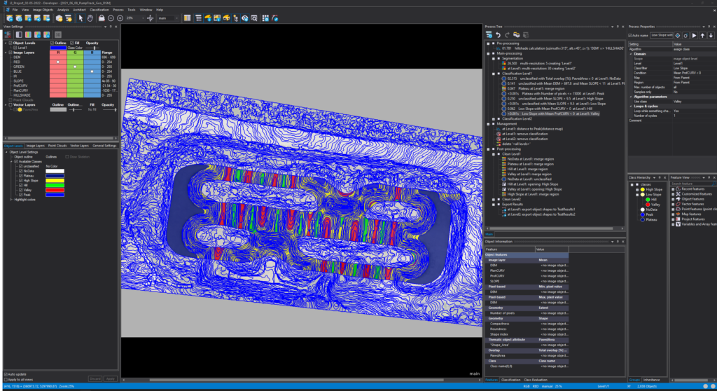
The general workflow of the project consisted out of two main parts taking place in two different software environments. The first part was conducted in ArcGIS Pro where the necessary layers for the following classification were derived. Additionally, a basic shape file was created that represented the extent of the area of interest to be analysed (pavement). The second part was conducted within eCognition Developer where the main analysis took place, containing the terrain segmentation and subsequent classification based on the previously derived terrain parameters. Finally, the classification results were exported as a shapefile.

More detailed descriptions for the creations of the analysis rulesets can be found on the GitLab wiki page of the project.
Results
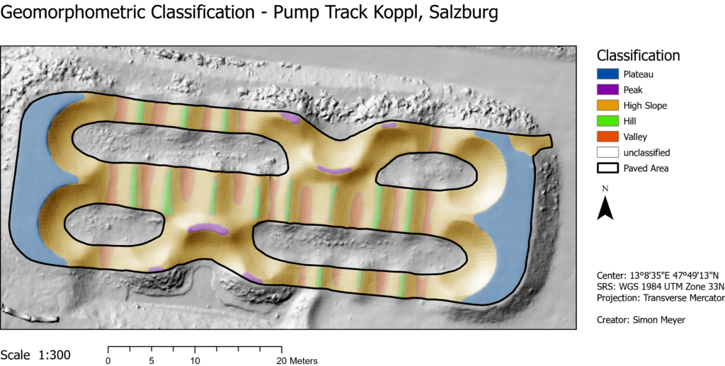
The result of the geomorphometric pump track analysis was a classified pump track area based on the various surface parameters and algorithms described in the previous project workflow section. The map below shows the results of the rulesets applied to the pump track in Koppl, which was the main goal of this project. The various attributes of the shapefile containing the classification results enables further geomorphological analysis in a GIS. Based on the legend visible in the map below, distinct forms and features of the pump track can be seen, including the elevated plateaus at both ends of the pump track, as well as smaller features such as roller and steps as defined in the initial sketch plan of the pump track project in Koppl.
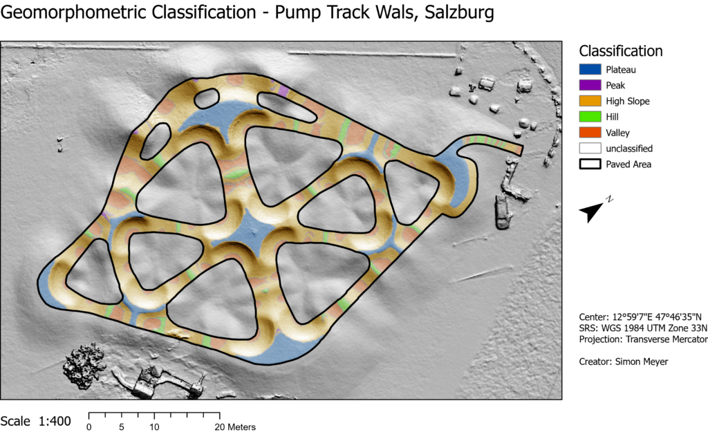
As the workflow of the pump track was in the most parts standardized, it can be easily adapted and transferred to other pump track projects. Still, two major restrictions remained: The area of interest has to be delineated manually in a GIS environment which requires next to eCognition another software product, as well as the usage of selected absolute values in the eCognition workflow. This made it necessary to adjust the workflow before transferring the workflow to another project setting. To test the transferability and quality of the classification schema, another pump track area (Wals, Salzburg) has been classified using the previously created ruleset. The result of the adjusted workflow can be seen above.
Conclusion
In the past, the OBIA method has been successfully used for landform extraction and surface classification. However, previous applications have predominantly been in larger scales. The application of OBIA for the geomorphometric analysis of pump tracks has shown that small-scale study areas can also be successfully captured and analysed. For the future, this promises a simpler and more reproducible method for the analysis of pump tracks, which can be easily applied through existing rulesets.
Based on the results, further research can be conducted regarding the effects of terrain types on the mountain biking experience. Additionally, geomorphometric analyses enable pump track designers to easily compare the construction results with the original sketch plans, which could lead to improved designs. The biggest current limitation is the limited transferability of the rulesets, as absolute values had to be used for the class thresholds (such as DEM height for classification of peaks). This limits the application to other study areas and makes a future revision of the classification scheme necessary.